Architect / Built Heritage Specialist
Full visualisations for this profile are available in the dedicated section:
Architect / Built Heritage Specialist graphs
A total of 39 respondents identified themselves as Architect or Built Heritage Specialist. This group represents professionals working on the documentation, analysis and management of historic buildings and built environments, often combining architectural practice with heritage conservation. Their responses reflect a domain where digital documentation tools are widely adopted, while monitoring systems and advanced digital workflows show more uneven levels of diffusion.
3.3.1 Digital tools, real–time data, monitoring, challenges
Architects and built–heritage specialists rely primarily on established digital documentation tools, with CAD, photogrammetry and 3D scanning forming the backbone of their workflows. More advanced environments such as BIM and GIS are adopted by part of the group, signalling a gradual transition toward integrated digital practices, though not yet universal. Real–time data collection is uncommon, with most practitioners relying on scheduled or manual acquisition rather than continuous sensor–based monitoring.
Structural and environmental monitoring practices follow a similar pattern: structural and geometric surveying tools are widely used, while environmental sensors, crack monitors and remote–sensing platforms appear only in a subset of cases.
The main difficulties in monitoring relate to cost, integration with traditional workflows and the interpretation and maintenance of digital monitoring systems, indicating a sector where digital documentation is mature but continuous digital monitoring remains unevenly supported.
3.3.2 Data types, formats, standards
Architects and built–heritage specialists work with a broad range of data (Figure 16), combining geometric and photographic documentation with historical records, material analysis and geospatial information.
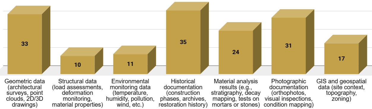
Figure 16. Data type.
These datasets, however, are stored predominantly in unstructured formats or proprietary software outputs, even when structured or 3D formats are available, creating a fragmented data landscape.
Interoperability practices remain limited: only a small subset of respondents reports using standards such as IFC, OGC specifications or CIDOC CRM, while most do not follow any formal protocol. Overall, the block reflects a domain with rich and diverse data but low standardisation and uneven digital structuring.
3.3.3 Data structuring, platforms, sharing challenges
Data accessibility among architects and built–heritage specialists is highly inconsistent: while some work within structured digital systems, an equal share operates across scattered or partially digitised datasets, and many still rely on unstructured or physical formats.
Collaborative platforms are used by a portion of respondents – both institutional and external solutions – while others remain interested but not yet engaged, and a smaller group does not perceive them as useful.
Data sharing (Figure 17) remains hindered by recurrent issues such as software and format incompatibilities, limited institutional infrastructure, legal restrictions and uneven collaboration across actors. Overall, the block highlights a persistent fragmentation in data organisation and a set of structural barriers that constrain fluid information exchange.
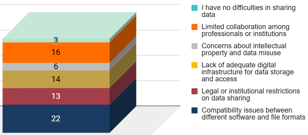
Figure 17. Main difficulties in sharing data.
3.3.4 3D models, simulations, integration challenges
The use of 3D models is nearly universal among architects and built–heritage specialists, with both frequent and occasional adoption forming the clear majority. Digital simulations show more varied uptake, with many respondents engaging with them occasionally or expressing interest without current implementation, indicating an emerging but still uneven practice.
Despite this relatively high level of digital engagement, significant barriers persist: high costs, limited technical expertise, interoperability issues and resistance to change all play a substantial role, while difficulties in interpreting or managing digital outputs further constrain integration. These patterns suggest a sector that is digitally active but still navigating structural and organisational obstacles that limit the full incorporation of advanced tools into routine workflows.
3.3.5 Digital Twin expectations, features, future outlook
Architects and built–heritage specialists show strong interest in Digital Twins across a wide range of applications, particularly for real–time condition monitoring, planning and testing conservation interventions, and integrating diagnostic and architectural data.
Expectations for a Reactive Digital Twin extend from access to up–to–date structural and environmental condition data to predictive modelling, virtual testing and the integration of historical documentation, with many respondents also highlighting the value of alerts and collaborative, interoperable models.
Looking ahead (Figure 18), most professionals anticipate a growing role for Digital Twins in architectural conservation, with many considering them essential tools for future preservation workflows, although some foresee adoption occurring only in specific contexts due to cost or complexity barriers.
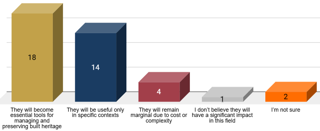
Figure 18. Future evolution of Digital Twin.
3.3.6 Cross–analysis insights
All detailed cross–tabulations for this profile are available in the corresponding section:
Architect / Built Heritage Specialist tables
These insights derive from comparative cross-tabulations across the profile-specific tables. The analysis focuses on relative response distributions within each row to identify structural patterns across technological groups, rather than relying on absolute counts.
-
Professionals who rely on photogrammetry, 3D scanning, CAD and BIM systematically work with a wide and diverse set of data – geometric, photographic, historical, material and geospatial. Across these tools, the relative distribution of data types remains highly consistent, suggesting a structurally homogeneous workflow. These tools act as the backbone of data–rich practices, while more specialised technologies generate narrower and more concentrated data profiles.
-
Advanced surveying tools and sensors are associated with high costs, technical maintenance burdens and integration issues with traditional workflows. Environmental sensing also shows elevated interpretation challenges. Monitoring difficulties therefore scale with tool sophistication, not with adoption frequency.
-
Even when 3D models, geospatial data or BIM formats are available, large portions of information still end up in unstructured or proprietary formats. Environmental monitoring data represent a partial exception, being more frequently stored in structured datasets. Overall, the digital ecosystem remains rich but poorly harmonised, with interoperability persisting as a key obstacle.
-
In the use of collaborative platforms, software compatibility emerges as the main reported sharing difficulty, while respondents not adopting such tools primarily indicate limited institutional collaboration rather than legal constraints. This suggests that technical interoperability and organisational fragmentation, rather than regulatory barriers, limit collaborative data sharing.
-
Across all technologies (Figure 19), continuous data collection remains marginal. Most tools operate either through manual post-processing (notably CAD) or through scheduled and campaign-based acquisition, confirming the limited integration of real-time sensor-based monitoring within architectural workflows.
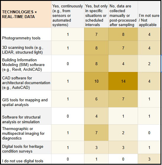
Figure 19. Cross-tabulation (digital technologies vs. data-collection methods).